Books & the Arts
/
May 14, 2026
The art and architecture of New York’s shoreline.
The art and architecture of New York’s vast and sweeping waterfront.

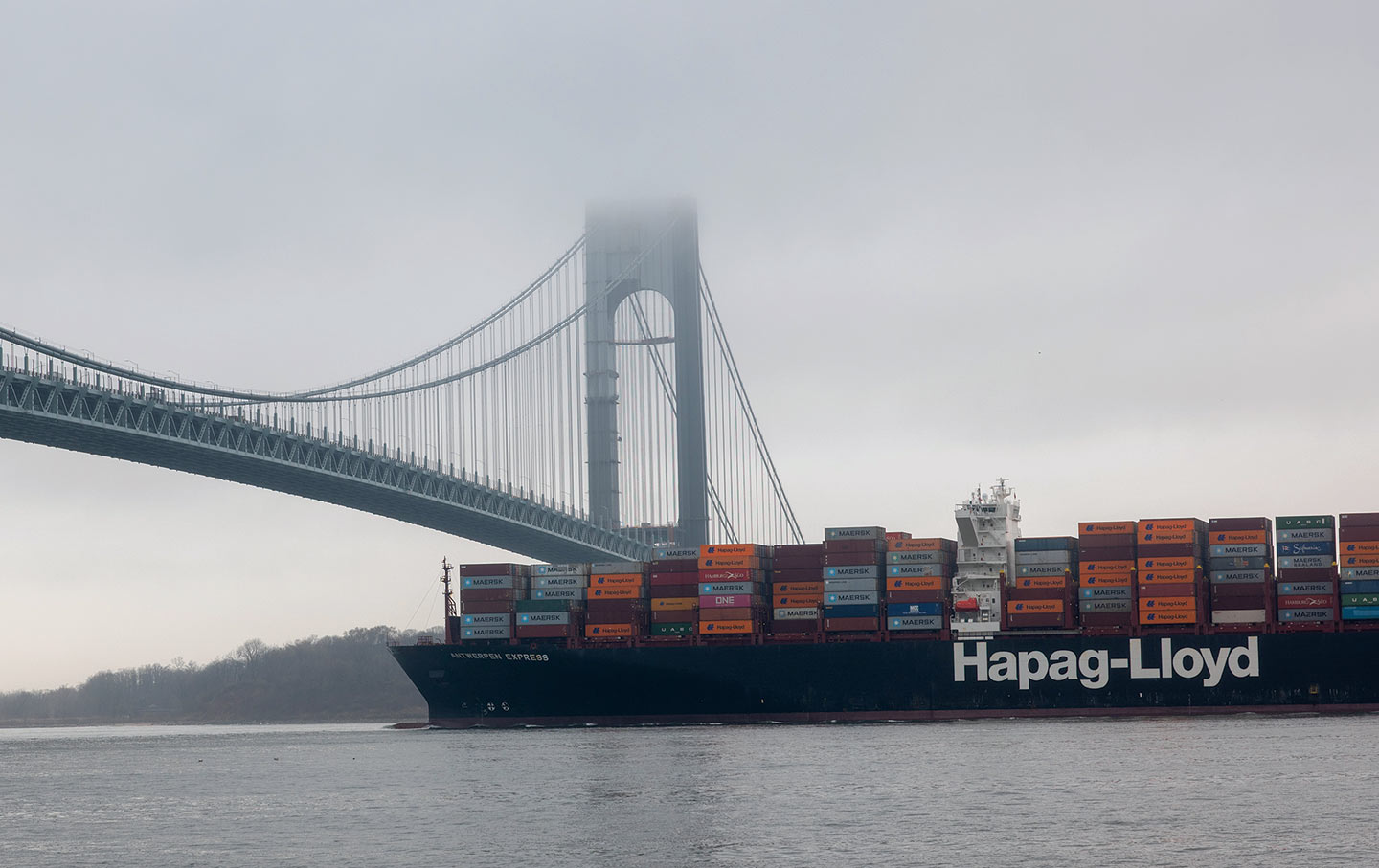
The Verrazano-Narrows Bridge spanning New York Harbor.
(Spencer Platt / Getty)
Last fall, I spent a glorious October Saturday walking the coast of Queens. It was one eight-mile segment of a monumental undertaking: a trek along the coastline of New York City. Cooked up by a group of artists called Works on Water and by New York’s Department of City Planning, the project was meant to help New Yorkers understand that we inhabit an island city, an urban archipelago with roughly 520 miles of shoreline. I was a latecomer to the walk but also right on time: I managed to show up for the final leg.
Like a lot of stories, this one began with a chance encounter. A little over a decade ago, I bumped into Nancy Nowacek on a street in Brooklyn’s Dumbo neighborhood. She’d been an art director at a magazine where I’d long written a regular column. But both of us had moved on, and she told me that she was working on a conceptual art piece, a footbridge across the Buttermilk Channel from Red Hook to Governors Island. She called it “Citizen Bridge” and was raising money by selling T-shirts that said Citizen in bold white type. (After Donald Trump started, in Nowacek’s words, “weaponizing the idea of citizenship,” she referred to the project simply as “The Bridge.”)
What I didn’t entirely comprehend at that moment was that Nowacek intended to actually build the bridge. Indeed, she spent several years working on the project full-time, writing grant proposals and giving lectures and putting up a Kickstarter page to support it. Along the way, she ran into other artists interested in working in and around the water and formed the group Works on Water. The experimental organization began hosting a triennial “dedicated to artworks, performances, conversations, workshops and site-specific experiences that explore diverse artistic investigation of water in the urban environment.”
Bringing artists together has its challenges, but getting the bridge approved and built turned out to be impossible. By 2016, Nowacek and her interdisciplinary team had developed several prototypes for a floating structure, yet she was hamstrung by the myriad regulations imposed on the 1,400-foot-wide waterway. But this impasse spawned something else: a partnership with the city and its planning department. “In doing the diligence, the seven or eight different permits that the bridge needed to get approved,” Nowacek explained, “I found myself in a meeting with Michael Marrella at City Planning. And I was spooling out the flow chart of how I understood this particular permit we were talking about, and the kind of contingencies and how to get to other permits. And he was like, ‘You know this better than some of my employees.’”
Marrella, for his part, was not especially encouraging about the prospects for Nowacek’s bridge. “One of the things I was trying to emphasize in that initial conversation,” he observed recently, “is that in New York City, every square inch of real estate is contentious and there are multiple objectives for any piece of land, but when it comes to the water’s edge and the water itself, that interest is magnified.” But Nowacek persevered, inserting herself into the world of waterfront planning and advocacy, attending endless meetings of organizations like the Waterfront Alliance, and soon she and the other water artists were solidifying their bond with the city planners and organizing a new project—what became the walk along New York’s 520-mile waterfront. “We had a first meeting with them in 2018,” Nowacek recalled. In a big tent on Governors Island, they gathered for what she calls Waterfront Planning Camp. The idea was that the artists could help do public outreach for the city’s forthcoming Comprehensive Waterfront Plan, and the best way to do that was to bring the artists (and the general public) to the water’s edge.
In January 2020, the city’s Department of Cultural Affairs announced that one of the Mayor’s Grants for Cultural Impact, in the amount of $50,000, would be given jointly to Works on Water, the Department of City Planning, and Culture Push (a nonprofit whose executive director, Clarinda Mac Low, is also a Works on Water artist). Walking the Edge was planned to encourage exploration, art, and activism tied to the city’s Comprehensive Waterfront Plan with an art piece consisting of artists walking the entire waterfront in shifts, 24 hours a day, for 20 days.
Current Issue

More precisely, the walk was slated to begin on May 20, or 5/20. “We were really thinking this was going to be come-one, come-all, 24 hours a day, seven days a week,” Nowacek recalls. She did the math and figured that, with teams walking 24 hours a day, the trek would take two weeks to complete. It would be an epic undertaking, like a Christo project but with people instead of billowing fabric. Two months before the walk was scheduled to begin, however, the world suddenly stopped. Says Nowacek with a sigh: “And then, the pandemic.”
In recent years, I’ve been writing and thinking about New York City’s waterfront: our propensity for building large amounts of housing on former industrial sites that are vulnerable to sea-level rise, the reclamation of waterfronts as parkland, the resilient (in theory) reconstruction of existing waterfront parks like those along the East River and Battery Park City…. It’s a big topic.
So I decided to spend the fall semester of 2025 with my School of Visual Arts graduate students exploring waterfront places and infrastructure. As I was drafting the syllabus, I received an e-mail promoting the 2025 Works on Water Triennial on Governors Island. I thought this would offer the students a different perspective on a topic we’d mostly be discussing with architects, and it would give us a good excuse to explore Governors Island. I contacted Nowacek, and she agreed to open the exhibit up on a Tuesday morning and talk with my class about the works on display.
I was impressed by the range and quality of the exhibition’s artworks, as were the students. There was, for example, an artist named sTo Len who made prints using the surface water of Newtown Creek, the notoriously polluted waterway separating Queens and Brooklyn, to create patterns on paper. And there was Sunk Shore, “a speculative, experiential tour of our climate crisis future” conducted by Carolyn Hall and Clarinda Mac Low at waterfronts around the city. (Mac Low described her work to me as “analog virtual reality.”)
But I found myself transfixed by an enormous grid of seemingly mundane snapshots. There were roughly 350 of them, showing what appeared to be random slices of the city. Some were recognizable—the Little Red Lighthouse overshadowed by the Great Gray Bridge—while others were just snippets of forlorn-looking beaches. Nowacek explained that each photo represented a mile walked by Works on Water artists and assorted friends of the project who were finally, five years after the pandemic began, Walking the Edge: “We started May 20th, 2025, and have been doing two walks every week since then.”
I asked if I could tag along and, in late October, joined an eight-mile exploration of the Queens shoreline that went from Fort Totten, a Civil War–era Army base now owned by the city, along Little Neck Bay, and through Douglaston. There were about a half-dozen of us, including Nowacek and Mac Low, a pollster named Carl Bialik (who’d been considering his own waterfront-walking project when he discovered Walking the Edge), his family (for a short stretch), and a South African friend. It was a lot like a carefree recreational jaunt, except that we paused every mile for someone to snap a photo to add to the grid.
I hadn’t spoken with Marrella at the time, so I didn’t understand that the walk was originally intended as an instrument of public engagement—one that, as he put it, “begins to plant a seed in the mind of the public to create an advocacy for the waterfront.” But the engagement happened nonetheless. Much of the walk was a blissful saunter along a footpath squeezed between the Cross Island Parkway and Little Neck Bay, one of those places that are at once quite beautiful but also emblematic of the way that planners (hello, Robert Moses!) used most if not all of New York City’s waterfronts as a handy conduit for highways. But it also served as a reminder that New York is, above all else, a city of waterfronts.
The biggest surprise was a neighborhood called Douglas Manor, an exclusive enclave on the water’s edge. There, stately homes were decked out in Halloween excess. What caught my attention, however, was something else—a set of nautical-looking blue-and-white signs posted at regular intervals that read: “Douglas Manor. Founded 1906. This private shoreline is owned and maintained by the Douglas Manor Association. For Member Use Only. No Trespassing.” It led me to wonder how much of the city’s shoreline is similarly off-limits. I was still stewing over the Douglas Manor beach grab when we rounded the tip of the neighborhood’s peninsula and discovered Udall’s Park Preserve, a public waterfront.
I looked it up later: Named for Richard Udall, who in the 19th century owned a mill on the cove, the preserve was the result of a group of local residents who “organized in 1969 in order to prevent development of the land and promote public ownership. Udall’s Cove was first mapped as a New York City park on December 7, 1972.”
Sadly, the come-one, come-all version of the 520-mile walk—a two-week extravaganza in which New Yorkers would have marched en masse along the water’s edge—never happened. Too bad. I suspect the project as originally conceived would have been a logistical nightmare, but also a phenomenon: a geekier, slower-moving answer to the New York City Marathon. And the press it surely would have generated could have drawn more attention to the 2021 Comprehensive Waterfront Plan, a document brimming with worthy ideas about resilience, water transportation, and job creation. Its underlying philosophy—that there’s no conflict between economic development and an environmentally thoughtful approach to waterways and wetlands—is, obviously, much needed right now.
Popular
“swipe left below to view more authors”Swipe →
But the experiential part of the project—walking the walk—was alchemy, transforming a policy initiative into a work of art. The thing Nowacek and Marrella have been saying for years—that there is a value that comes from knowing the waterfront—was obvious even during this one afternoon. Clearly, both the people who came up with the idea that Douglas Manor’s mile of beach should be private, cooperatively held by the homeowners, and those who fought to establish Udall’s Cove as a public park knew their waterfronts. And the spot where the day’s walk came to an end was, happily, a section of Udall’s Cove called Virginia Point. It’s a smidgen of wilderness on a Little Neck Bay inlet, a spot so bucolic that it couldn’t possibly be in New York City. But, of course, it is. And it was hard to imagine a section of waterfront that better expressed the magic of the project.
I was eager to sign up for the next leg, but when Nowacek played Ace Frehley’s version of “New York Groove” on her iPhone—the same song she’d used to mark the conclusion of the very first segment—and everyone did a brief celebratory dance, I was sorry to realize that we had arrived at mile 520, and that the walk along the city’s edge was over.
From illegal war on Iran to an inhumane fuel blockade of Cuba, from AI weapons to crypto corruption, this is a time of staggering chaos, cruelty, and violence.
Unlike other publications that parrot the views of authoritarians, billionaires, and corporations, The Nation publishes stories that hold the powerful to account and center the communities too often denied a voice in the national media—stories like the one you’ve just read.
Each day, our journalism cuts through lies and distortions, contextualizes the developments reshaping politics around the globe, and advances progressive ideas that oxygenate our movements and instigate change in the halls of power.
This independent journalism is only possible with the support of our readers. If you want to see more urgent coverage like this, please donate to The Nation today.
More from The Nation
Poetry, perhaps more than any other genre, shows us how important it is to connect with a real human presence.
Lindsay Turner
The postmodern writer’s 1968 baseball novel is strange and poignant—a work of fiction that ultimately argues for the vitality of fiction itself.
Books & the Arts
/
John Semley
In Miracle Children: Race, Education, and a True Story of False Promises, two reporters uncovered a high school scandal that puts into relief the unfinished work of integration.
Books & the Arts
/
Kristen Martin