Early in the morning on August 10, 2025, Christine Smith awoke in a boat anchored in an inlet along southeast Alaska’s glacier-threaded coast. Smith and her husband were leading a small cruise on their 65-foot wooden boat, the David B. Inclement weather had forced them to spend the night 50 miles from their planned anchor spot in Tracy Arm, a dramatic fjord to the southeast of Juneau. As the naturalist and chef on board, Smith prepared to make breakfast and write about the rainy, foggy conditions in her daily log. Her husband, the captain, got her attention, asking, “Have you ever seen this before?”
From the boat, they could see water foaming over a nearby sandbar and repeatedly surging over, then retreating from, large rocks on the shoreline. The tide should have been falling. Perplexed, Smith texted her friend Jackie Caplan-Auerbach to see if the Western Washington University seismologist might know if this odd ebbing and flowing could be the result of a nearby landslide.
From what Caplan-Auerbach and other scientists pieced together in the hours and days that followed, Smith learned that if the David B had anchored in Tracy Arm as planned, she and the others aboard would have been killed. A loud crash around 5:30 A.M. Alaska Time would have awoken them as the north fjord wall crumbled just in front of the retreating tongue of the South Sawyer Glacier. They likely would have seen a deadly 300-foot wall of water heading their way. Their near miss underscores the threat to ships and local communities as retreating glaciers destabilize the landscape. But new research by Caplan-Auerbach and many others, published today in Science, shows that subtle clues could help provide early warnings.
On supporting science journalism
If you’re enjoying this article, consider supporting our award-winning journalism by subscribing. By purchasing a subscription you are helping to ensure the future of impactful stories about the discoveries and ideas shaping our world today.
What Caused the Collapse
Over the past two decades, as the climate has continued to warm, most of Alaska’s coastal glaciers have retreated, exposing steep, U-shaped fjord walls. Researchers have been concerned that without their icy buttresses, these walls could collapse. They’ve largely focused on areas already showing signs of instability, such as a slowly degrading slope in Barry Arm in south-central Alaska, where a massive landslide could send a destructive tsunami to the town of Whittier 30 miles away in just 20 minutes. “We have our eyes on a very small number of potential slides, and there are obviously way, way more,” Caplan-Auerbach says.
But the Tracy Arm tsunami shows that not all fjords exhibit slow collapse. “At Tracy Arm, there’s no indication that that was the case,” says Dan Shugar, a geomorphologist at the University of Calgary in Alberta and lead author of the new study, which is also being presented today at the annual meeting of the European Geosciences Union in Vienna.
An animation of the landslide and tsunami in Tracy Arm.
Over the past year, Shugar and his co-authors have dug more deeply into seismic records and other observations of the glacier to figure out what happened. They found that South Sawyer Glacier has undergone long-term thinning and retreat over the last century. More acute episodes of shrinking have been documented since 2000. In the spring and summer of 2025, the ice retreated inland several hundred feet at the base of the collapsed slope, exposing most of the rock that ultimately caused the landslide just days before the sudden collapse. “It’s quite a direct link,” says Kristen Cook, a geomorphologist at University of Grenoble Alpes in France, who wasn’t involved in the study.
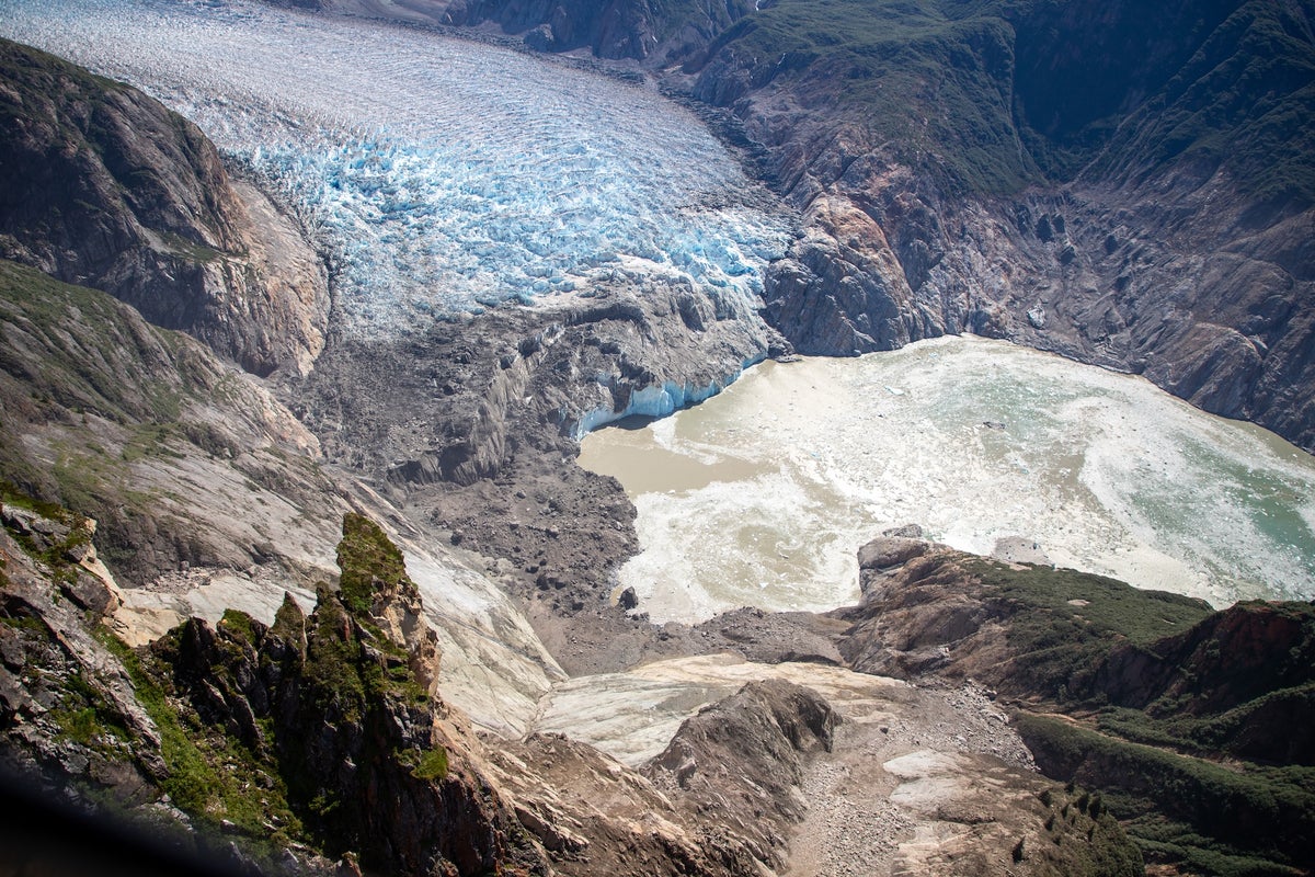
Using imagery and digital elevation models from before and after the slide, the researchers estimate that at least 2.26 billion cubic feet of earth collapsed, resulting in a loss of about 500 feet of coastline. They think the rupture likely extended even farther below the water’s surface but lack the bathymetry data to prove this. The resulting tsunami reached more than 1,500 feet up the side of the fjord and sloshed back and forth like bathtub water, creating a seismic “ringing” that could be detected around the world for up to 36 hours.
Subtle Seismic Signals
Though the collapse and tsunami in Tracy Arm took everyone by surprise, such events might still have warning signs—just very subtle ones. Caplan-Auerbach just happens to study the microseismic precursors to landslides, so when she got that initial text from Smith, she started digging into seismic data from nearby stations. The big slide at Tracy Arm produced a signal equivalent to a magnitude 5.4 earthquake, but much smaller events occurred at least 24 hours prior, increasing exponentially in intensity six hours before the landslide. The pattern in this case matched other landslides Caplan-Auerbach has observed. She says more research is ongoing, but it seems these signals could happen as a slab of rock starts slipping, then jerking to a stop, then slipping again.
“We’d love to identify precursors as early as possible, with the eventual goal of assessing where and when a landslide would occur,” she says. “It’s possible that they occur prior to most slides, but we don’t have enough seismic data to detect them. It’s also possible that they only happen under specific circumstances.”

Sawyer Island seen in 2022, prior to the tsunami, with trees and shrubs. South Sawyer Glacier is in the background.
Christine Smith on the MV David B
Separately, seismic signals produced during a landslide could be useful for early tsunami warning systems. Unlike earthquakes, landslides often are not detected right away because the ground vibrations emerge relatively slowly, not “impulsively” like an earthquake. Their signals are more likely to be noticed in the seismic data after the fact, if enough energy was generated to be picked up by the nearest seismic stations. Another author on the new study, Ezgi Karasözen, a research seismologist at the Alaska Earthquake Center, has been testing a landslide detection algorithm that was developed for the area around Prince William Sound off the Gulf of Alaska.
So far the experimental system has detected 35 landslides in near real time. “We would ideally have a notification of it within three to four minutes of something like this happening,” Karasözen says, which could make all the difference for communities such as Whittier. But the system does not cover the area around Tracy Arm, so when Karasözen tried to pinpoint its source, their initial estimate of the location was about four miles off. “I think now with the Tracy Arm event, everyone is trying to figure out, what can we do to better characterize this hazard and then figure out a way forward?” Karasözen says. Adding more seismic stations, especially in southeast Alaska, could help, though that can be costly amid the harsh terrain. “That’s why improving detection algorithms to better use the existing network is just as important as expanding it,” she says.
In the Aftermath
A day after the landslide, Smith and her passengers navigated into Tracy Arm and saw the aftermath of the massive wave. Along beaches that had been stripped of their vegetation, icebergs sat incongruously high on rocks. Mature hemlock and spruce trees had been “tumbled and pummeled” with their bark and branches sheared off, she said. Moss, sticks and other debris floated in the water while the South Sawyer Glacier, usually brilliant blue, was coated in a layer of dust.

Sawyer Island, stripped of all but a couple of trees, captured during a U.S. Geological Survey field reconnaissance overflight on August 13, 2025. The walls behind it have also been partially stripped of vegetation.
John Lyons/U.S. Geological Survey
More than 20 vessels usually visit Tracy Arm and nearby Endicott Arm every day in the summer, including up to six large cruise ships, some carrying 6,000 passengers and crew. Those large cruise operators have said that they are avoiding Tracy Arm for this upcoming summer tourist season. Smith visited a few more times this past fall, but she doesn’t plan to return this summer. She described feeling a bit of sadness after her near miss—and a loss of “trust” in these environments she’s become so comfortable in—but she’s still committed to experiencing and sharing the wonder of the region.
“We all go to these beautiful places because we want to experience the beauty, and we want to be humbled by nature,” Smith says. “That scar that is there by the glacier is always going to be a reminder that this has happened there, and it can happen anywhere else.”